
Service Areas — Montana
Drone LiDAR Mapping Services in Montana
Utah LiDAR mobilizes from the Uintah Basin for qualifying drone LiDAR and RTK field-data collection projects throughout Montana. We support Professional Land Surveyors, civil engineering firms, contractors, developers, mining and aggregate operations, utilities, energy companies, municipalities, forestry-related projects, ranch properties, and infrastructure teams with dense terrain and existing-condition data.
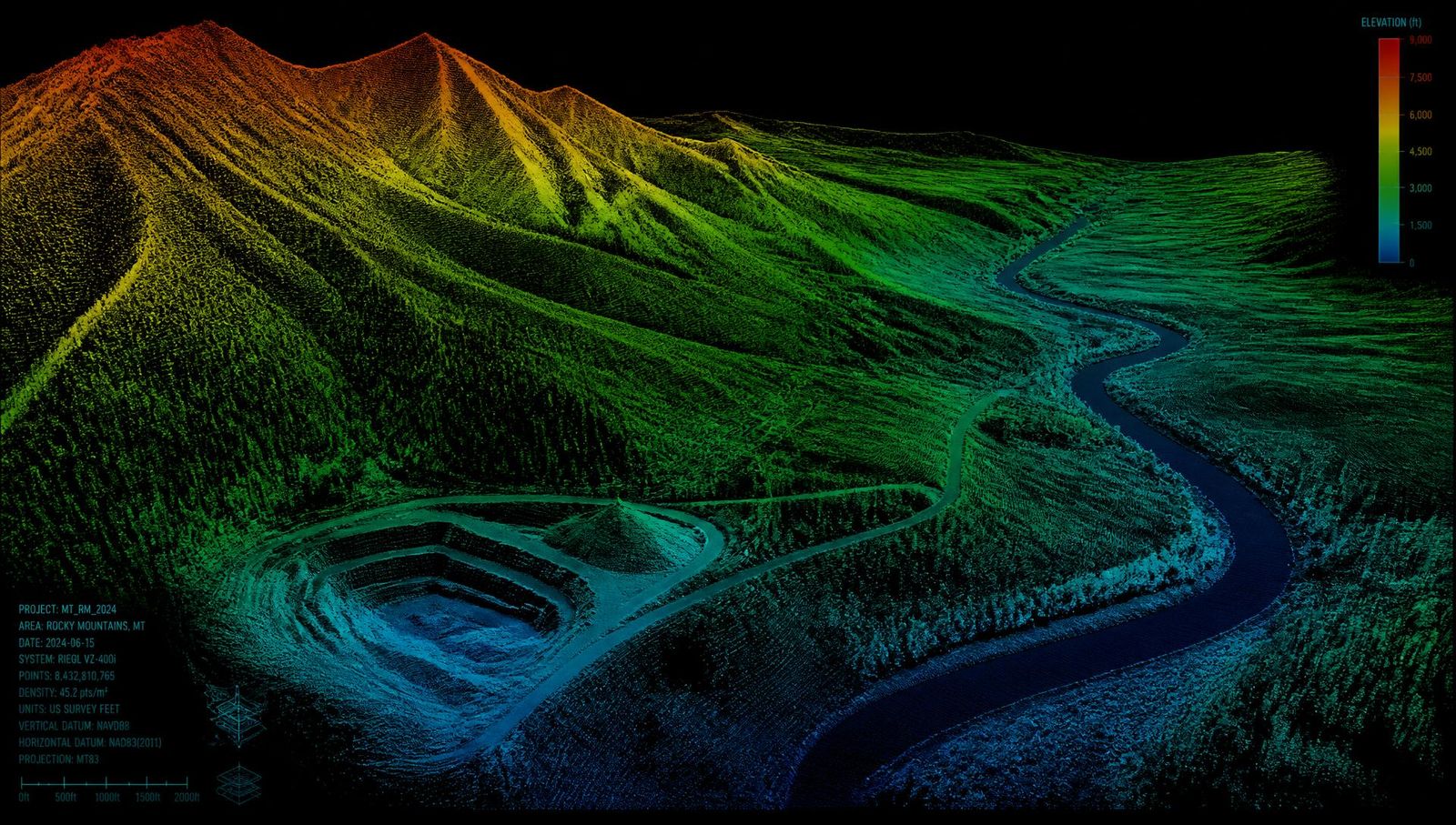
Drone LiDAR across Montana
Montana projects may include mountain and forest terrain, mines, quarries, aggregate yards, roadways, utility corridors, energy infrastructure, large ranch properties, rural development, construction sites, and remote project areas. Every project is scoped around terrain, vegetation, elevation, weather, site access, project control, required accuracy, airspace, coordinate systems, processing requirements, and final deliverables.
Utah LiDAR does not maintain a Montana office, branch, or permanent field crew. Montana work is scheduled as a planned mobilization from our Uintah Basin base, which is why site limits, access, snow and smoke windows, and deliverables are confirmed before a collection date is set.
Where we provide LiDAR services in Montana
We travel to qualifying projects throughout Montana. Mobilization depends on project location, project size, travel distance, site access, weather, airspace, terrain, existing control, and the deliverables the project team needs.
Southwestern Montana
Bozeman, Belgrade, Livingston, Butte, Dillon, Big Sky, and the surrounding communities. This is some of the fastest-changing ground in the state, and a site can shift substantially between design and construction. Steep terrain, mountain valleys, high elevation, forested slopes, winter weather, seasonal access, and active construction all shape when a collection can be flown and how much bare-earth data a flight returns.
- Residential and commercial land development
- Mountain construction
- Civil engineering projects
- Road and access-route mapping
- Utility corridors
- Mass grading
- Drainage and slope documentation
- Mining and aggregate operations
- Large rural properties
- Contract LiDAR support for survey firms
Western Montana
Missoula, Kalispell, Whitefish, Hamilton, Polson, Libby, and the surrounding valleys. Dense evergreen canopy is the defining planning factor here — usable ground returns depend on canopy density, season, and terrain. Steep slopes, mountain weather, snow, wildfire-affected ground, river valleys, and seasonal road access also affect flight design and scheduling.
- Forested-terrain mapping
- Mountain and valley development
- Road and utility corridors
- Forestry-related projects
- Large rural properties
- Aggregate and quarry sites
- Existing-condition mapping
- Construction as-builts
- Drainage and slope documentation
- Remote-site collection
Central Montana
Helena, Great Falls, Lewistown, Havre, and the surrounding communities. Open plains and foothills make large-area collection efficient, but wind exposure is persistent, travel distances between sites are long, and rural access roads can control the schedule as much as the weather. Mixed agricultural and industrial landscapes are common on a single project.
- Civil and municipal projects
- Roadway and transportation corridors
- Utilities and transmission
- Wind-energy projects
- Large ranch properties
- Aggregate stockpiles
- Earthwork quantities
- Industrial sites
- Construction progress
- Large-area topographic mapping
Eastern Montana
Billings, Miles City, Glendive, Sidney, Wolf Point, and the surrounding region. Open plains, badlands, and river corridors sit alongside energy infrastructure and large ranch acreage. Long distances between services, strong wind, extreme seasonal temperatures, and remote access mean logistics are reviewed before a schedule is set.
- Energy and infrastructure projects
- Pipeline and utility corridors
- Mining and aggregate
- Roadways
- Industrial development
- Large ranch properties
- Construction and earthwork
- Stockpile measurement
- Existing-condition mapping
- Remote-site documentation
Mobilization & scheduling
Utah LiDAR mobilizes to qualifying Montana projects from its home base in the Uintah Basin. Southern Montana may involve shorter travel than northern, northwestern, or far-eastern Montana, but every project is scheduled and priced individually. Multiple sites within the same Montana region can often be combined into one mobilization when schedules and site readiness align. Out-of-state project minimums, travel charges, or mobilization fees are determined during project scoping and included in the written quote. Same-day or next-day service is not offered.
Scheduling depends on
- Distance from the Uintah Basin
- Project acreage
- Corridor length
- Number of sites
- Site access and road conditions
- Terrain and elevation
- Vegetation and canopy
- Snow, wind, cold, smoke, and weather
- Airspace
- Land ownership or access requirements
- Existing survey control
- Required accuracy
- Requested deliverables
- Processing complexity
- Project schedule
LiDAR services available in Montana
Montana services are customized around the intended use of the data, terrain, vegetation, site access, existing control, required accuracy, coordinate system, processing requirements, and final deliverables rather than a fixed package.
Drone LiDAR Mapping in Montana
Drone LiDAR supports large ranch properties, mountain terrain, forested areas, mines, aggregate yards, roadways, utility corridors, construction sites, energy infrastructure, development projects, and difficult-access locations. On suitable large, steep, forested, or remote Montana sites, dense aerial collection may reduce the amount of conventional point-by-point fieldwork required.
See how drone LiDAR mapping works →LiDAR Topographic Mapping in Montana
Deliverables may include classified point clouds, bare-earth terrain models, existing-ground surfaces, contours, breaklines, and preliminary linework for surveying, civil engineering, grading, drainage, roadway, development, energy, forestry, mining, and infrastructure workflows. Final survey products may require review and certification by a Montana-licensed Professional Land Surveyor.
Review our LiDAR topographic mapping capabilities →Stockpile and Pit Volume Surveys in Montana
Aggregate stockpiles, sand and gravel, mine stockpiles, quarries, borrow and spoil piles, excavation pits, industrial material yards, reclamation materials, repeat inventory programs, and pit progression. LiDAR measures geometry and volume; any tonnage estimate requires a client-supplied or client-approved material density.
Explore stockpile and pit volume services →Earthwork and Cut-and-Fill Measurement in Montana
Current surfaces can be compared with original ground, previous collections, approved design surfaces, reclamation surfaces, or a defined base surface for site grading, excavation, fill placement, road construction, contractor quantities, mine development, reclamation, utility construction, progress tracking, site balancing, and final-grade comparisons.
Explore earthwork measurement services →As-Built and Existing-Condition Documentation in Montana
LiDAR can document existing terrain before construction and visible completed improvements afterward — roads, pads, grading, drainage, retaining structures, industrial facilities, utility corridors, pipelines while still visible, municipal improvements, development sites, and energy facilities. LiDAR cannot detect buried utilities or pipelines concealed by soil.
See as-built and existing-condition mapping →Contract LiDAR Support in Montana
Project-based field capacity for Montana firms needing specialized LiDAR equipment, additional collection support, remote mobilization, forested-site mapping, steep-terrain coverage, or large-site acquisition: LiDAR acquisition, RTK control and checkpoints, classified point clouds, terrain surfaces, contours, breaklines, preliminary linework, volume calculations, and white-label support if confirmed. Your Professional Land Surveyor remains responsible for professional judgment, review, certification, and stamping when required.
See contract LiDAR support for surveying firms →Montana industries we support
Civil Engineering and Land Development in Montana
Residential development, commercial sites, mountain and resort-area development, industrial sites, roadways, grading, drainage and stormwater, utilities, municipal improvements, site planning, and construction documentation all start from current ground. Classified point clouds, terrain models, existing-ground surfaces, contours, breaklines, and CAD-compatible files move straight into engineering and design workflows without a separate conversion step.
- Existing-ground surfaces
- Subdivision and commercial site topography
- Mountain and resort-area development
- Roadway and corridor terrain
- Grading, drainage, and stormwater data
- Utility and municipal improvements
- Civil 3D-compatible deliverables
Mining, Quarries, and Aggregate in Montana
Montana operations measure the same ground repeatedly. Drone LiDAR supports stockpile inventories, pit progression, quarry mapping, material volumes, excavation quantities, haul-road documentation, reclamation surfaces, material reconciliation, repeat measurements, and surface-change documentation across large industrial sites. Repeatable flight plans keep each cycle directly comparable. We do not claim work at any specific Montana mine, quarry, aggregate yard, or processing facility.
- Stockpile inventories
- Pit progression and excavation quantities
- Quarry and aggregate mapping
- Haul roads
- Reclamation surfaces
- Material reconciliation
- Repeat measurement programs
Construction and Earthwork in Montana
Preconstruction baselines, mass grading, excavation, fill placement, contractor quantity review, progress measurement, stockpile tracking, design-surface comparisons, and final-condition documentation. Remote construction sites, mountain projects, and rural jobs are exactly where a single aerial collection replaces days of walking a site with a rover.
- Preconstruction existing-ground baselines
- Mass grading and excavation quantities
- Fill placement and site balancing
- Contractor quantity review
- Progress and stockpile tracking
- Design-surface comparisons
- Final-condition documentation
Forestry, Vegetation, and Wildfire-Affected Terrain in Montana
Potential applications include forested-terrain mapping, bare-earth terrain modeling where sufficient ground returns exist, road and access-route mapping, utility corridors, watershed terrain, slope documentation, post-wildfire terrain change, remote infrastructure planning, large-property topography, and vegetation-related point-cloud classifications when included in scope. LiDAR does not completely penetrate dense tree canopy. Utah LiDAR supplies terrain and point-cloud data for review by the appropriate professionals and does not provide forestry, hydrology, wildfire-risk, or engineering conclusions.
- Forested-terrain point clouds
- Bare-earth models where ground returns allow
- Road and access-route mapping
- Utility corridors through timber
- Watershed and slope terrain
- Post-wildfire terrain change
- Vegetation classifications when scoped
Energy, Pipelines, and Utilities in Montana
Pipeline corridors, transmission and distribution lines, substations, access roads, energy facilities, wind-energy sites, utility construction, existing conditions, grading and drainage, construction progress, and as-built documentation of visible improvements. LiDAR records what is visible at the time of flight — it cannot detect buried pipelines or utilities once they are covered.
- Pipeline and transmission corridors
- Substations and facility sites
- Wind-energy site terrain
- Access roads and pads
- Grading and drainage data
- Construction-progress collection
- As-built documentation of visible work
Municipal, Roadway, and Transportation Projects in Montana
Roads, public works, drainage, bridges and approaches where visible, utility corridors, municipal facilities, site planning, construction documentation, existing-condition mapping, and rural transportation routes. Utah LiDAR supplies field data and preliminary deliverables only — engineering design, bridge inspection conclusions, and stamped survey documents are the responsibility of appropriately licensed professionals.
- Roadway and corridor terrain
- Public works and municipal facilities
- Drainage and stormwater data
- Visible bridge approaches
- Utility corridors
- Rural transportation routes
- Existing-condition mapping
Land Surveying Firms in Montana
Contract field capacity for firms that need LiDAR collection without adding equipment or crew: LiDAR acquisition, RTK support and checkpoints, classified point clouds, terrain surfaces, contours, breaklines, preliminary linework, and volume calculations prepared for the client's licensed surveyor. Professional judgment, review, certification, and stamping remain with your PLS.
- Project-based LiDAR acquisition
- RTK control and checkpoints
- Classified point clouds
- Terrain surfaces and contours
- Breaklines and preliminary linework
- Volume calculations
- Deliverables formatted for your workflow
Ranch, Agricultural, and Large Rural Properties in Montana
Potential applications include large-area topographic mapping, access-road planning, drainage and terrain documentation, development planning, utility corridors, construction baselines, earthwork quantities, remote property mapping, visible irrigation or water-conveyance infrastructure, and existing-condition documentation. LiDAR is not a substitute for boundary surveying, agricultural consulting, water-rights analysis, or engineering.
- Large-area topographic surfaces
- Access-road and route planning
- Drainage and terrain documentation
- Development planning data
- Utility corridor terrain
- Visible irrigation infrastructure
- Existing-condition documentation
Montana Terrain and LiDAR Collection Conditions
Montana projects may involve Rocky Mountain terrain, forested slopes, open plains and prairie, river valleys, badlands, steep canyons, and high elevation. Add deep seasonal snow, strong wind, extreme cold, hot and dry summer conditions, wildfire smoke and wildfire-affected terrain, large ranch properties, remote industrial sites, long distances between services, seasonal road closures, active mines and construction sites, controlled or restricted airspace, and federal, state, tribal, municipal, and privately managed lands, and the planning picture changes from site to site. Those conditions influence mobilization planning, flight timing, flight altitude, point density, flight overlap, ground control, GNSS performance, site access, line-of-sight planning, battery and equipment logistics, safety requirements, collection windows, and processing and classification — so each Montana project is planned around its own site rather than a standard flight profile.
- Rocky Mountain terrain and forested slopes
- Open plains, prairie, and badlands
- River valleys and steep canyons
- High elevation and deep seasonal snow
- Strong wind and extreme cold
- Hot, dry summers and wildfire smoke
- Wildfire-affected terrain
- Large ranch properties and remote industrial sites
- Long distances between services and seasonal road closures
- Federal, state, tribal, municipal, and private land access
LiDAR may collect ground returns through openings in grasses, brush, and tree canopy, but it does not see through every type of vegetation. Bare-earth data quality depends on canopy density, season, terrain, sensor performance, flight configuration, and actual ground visibility.
Snow generally causes LiDAR to represent the visible snow surface rather than the bare earth beneath it, so snow-free conditions may be necessary for true terrain mapping, stockpile measurement, or earthwork comparison. Strong winds and mountain turbulence may delay or limit safe operations, and cold temperatures may affect batteries, equipment performance, crew safety, and flight duration.
Wildfire smoke, active fire restrictions, temporary flight restrictions, and poor visibility may affect scheduling and safe collection. Dense evergreen canopy may produce fewer usable ground returns than open or seasonally sparse vegetation, and remote sites may require additional planning for access, communications, fuel, lodging, and equipment support. No universal accuracy figure applies to every Montana site — expected accuracy is defined during scoping around control, terrain, and intended use.
How projects work in Montana
Define the project
Review the Montana project location, project limits, acreage or corridor length, intended use, terrain, vegetation, access, required accuracy, coordinate system, existing control, site restrictions, schedule, and deliverables.
Plan control and collection
Account for elevation, canopy, wind, snow, temperature, wildfire conditions, airspace, flight height, point density, overlap, existing survey control, RTK requirements, remote-site logistics, land access, and site hazards.
Collect and process the data
Collect LiDAR and RTK data, register the point cloud, review data quality, classify returns, and prepare the agreed terrain, surface, quantity, or mapping outputs.
Prepare project deliverables
Prepare point clouds, surfaces, contours, breaklines, quantities, CAD files, comparison maps, and project exhibits in the agreed formats.
Deliver for professional review
Deliver files to the client's Professional Land Surveyor, civil engineer, contractor, developer, mine operator, energy company, municipality, utility, land manager, or authorized project team. Professional land-surveying review, certification, or stamping must be completed by an appropriately licensed professional when required.
Deliverables in Montana
Deliverables are scoped per project and may include any of the following. The final package depends on the scope agreed before collection.
Classified Point Clouds
LAS or LAZ point clouds classified according to the agreed project scope.
Digital Terrain and Surface Models
Bare-earth terrain models, digital surface models, TINs, and existing-ground surfaces.
Contours and Breaklines
Contours at an appropriate interval, terrain breaklines, and preliminary linework based on project requirements.
Volume and Difference Reports
Stockpile volumes, pit quantities, cut-and-fill summaries, and surface-comparison exhibits.
CAD and Civil 3D-Compatible Files
DWG, DXF, LandXML, CSV, LAS/LAZ, raster, or other agreed formats.
Project Exhibits
PDF maps, quantity tables, elevation-difference maps, and visual summaries for project review.
Montana LiDAR services: frequently asked questions
Where does Utah LiDAR provide services in Montana?
Utah LiDAR mobilizes to qualifying projects in southwestern Montana around Bozeman, Butte, and the surrounding mountain valleys, western Montana near Missoula and the Flathead region, central Montana around Helena and Great Falls, eastern Montana near Billings and the energy country beyond it, and other regions based on project scope.
What types of Montana projects use drone LiDAR?
Land development, civil engineering, construction and earthwork, mining and aggregate operations, forestry-related projects, utilities and pipelines, municipal work, roadway corridors, energy infrastructure, large ranch properties, remote terrain, and mountain sites. The right approach depends on the intended use of the data, terrain, vegetation, required accuracy, and deliverables.
Can LiDAR map forested or mountainous terrain in Montana?
Drone LiDAR is well suited to collecting dense terrain data across many steep or vegetated sites where conventional fieldwork is slow or unsafe. Canopy density, elevation, terrain, weather, access, airspace, and ground visibility all affect the collection plan, the number of flight days, and the resulting data.
Can LiDAR collect bare-earth data beneath Montana forests?
Some laser pulses may reach the ground through openings in tree canopy and understory vegetation, which is why LiDAR often outperforms photogrammetry in timber. The amount of usable ground data depends on canopy density, season, species, terrain, sensor performance, flight design, and actual ground visibility. LiDAR does not see through all forest canopy, and dense evergreen stands may return fewer ground points than open or seasonally sparse cover.
How does snow affect a Montana LiDAR project?
LiDAR generally measures the visible snow surface rather than the soil beneath it. Snow-free conditions may be necessary for true bare-earth terrain mapping, stockpile measurement, or earthwork comparison, which is why many Montana scopes are planned around the snow-free window for the specific elevation and region.
How do wind and cold affect drone LiDAR collection?
Wind, mountain turbulence, cold temperatures, icing conditions, battery performance, crew safety, and equipment limits may all affect collection windows, flight duration, data quality, and scheduling. We do not publish universal operating limits — those depend on the specific equipment and the conditions on site the day of the flight.
Can Utah LiDAR measure Montana stockpiles, pits, and quarries?
Yes. Stockpile surfaces can be measured against a defined base surface, pits can be tracked through progression, excavation quantities can be calculated, reclamation surfaces can be compared to prior collections, and repeat inventory flights keep the numbers comparable over time. LiDAR measures geometry and volume; tonnage requires a client-supplied or client-approved material density.
Can LiDAR support pipeline, utility, and energy projects in Montana?
Potential applications include corridor topography, access-road mapping, facility and substation sites, terrain surfaces, grading and drainage data, construction-progress collection, earthwork quantities, and as-built documentation of visible infrastructure. LiDAR cannot detect buried pipelines after they are covered, and no experience on a specific named project is claimed.
Can LiDAR support ranch or large rural property projects?
Potential applications include large-area topographic mapping, access roads, drainage and terrain documentation, utility corridors, development planning, construction baselines, earthwork quantities, and visible water-conveyance infrastructure. LiDAR does not replace boundary surveying or professional engineering — those require an appropriately licensed professional.
Can LiDAR data be used in Civil 3D?
Yes. Deliverables may include LAS or LAZ point clouds, DWG, DXF, LandXML, CSV, existing-ground surfaces, contours, breaklines, and other agreed formats. Coordinate system, datum, classification level, and file formats are confirmed during project scoping.
Does Utah LiDAR provide stamped land surveys in Montana?
No. Utah LiDAR provides LiDAR and RTK field-data collection, processing, and preliminary project deliverables. Any work requiring professional land-surveying judgment, certification, or sealing must be completed by an appropriately licensed Professional Land Surveyor.
Can Utah LiDAR operate in controlled airspace or on public or tribal land?
Drone operations may depend on airspace classification, required authorizations, land ownership, agency or tribal requirements, site restrictions, operating conditions, and applicable regulations. Montana projects frequently touch federally managed, state, and tribal ground, so these factors are evaluated before a project is scheduled and some sites require additional lead time or permissions.
How do wildfire smoke or active fire conditions affect collection?
Smoke may reduce visibility and create operational or airspace restrictions. Active fire conditions, temporary flight restrictions, road closures, crew safety, and land-access limitations may prevent or delay collection, so late-summer scheduling is reviewed against current conditions.
How long does it take to mobilize to Montana?
Timing depends on project location, size, travel distance, road conditions, site access, vegetation, snow, wind, cold, smoke, terrain, airspace, control requirements, equipment availability, processing scope, and deliverables. Montana work is scheduled as a planned mobilization, not same-day or next-day service.
What information is needed for a Montana LiDAR quote?
Project location, project boundary, acreage or corridor length, intended use, required accuracy, existing control, coordinate system and datum, requested deliverables, terrain and vegetation, snow or seasonal site conditions, site access and road conditions, known airspace or land restrictions, and desired schedule. A KMZ, KML, shapefile, CAD file, or marked map is helpful when available.
Other service areas
← All service areasRelated services
LiDAR Services Available in Montana
Every Utah LiDAR service is available on Montana project sites, from drone LiDAR mapping and topographic surfaces to stockpile volumes, as-builts, and contract support for surveying and engineering firms.
Drone LiDAR Mapping
UAV LiDAR surveying and aerial LiDAR services across Utah and the Intermountain West. RTK-controlled drone LiDAR mapping with CAD-ready deliverables in days.
Topographic Mapping
Drone topographic survey and terrain mapping services: bare-earth DTMs, contours, breaklines, spot elevations, and CAD-ready surfaces for civil design.
Stockpile Volumes
Drone stockpile surveys and volumetric calculations for aggregate, frac sand, quarry, and mine operations. Repeatable monthly material inventory you can bill against.
As-Built Surveys
Drone LiDAR as-built surveys and existing conditions documentation for construction verification, post-construction records, and pre-construction baselines.
Earthwork & Cut/Fill
Cut and fill surveys, earthwork volume calculations, and progress quantity verification using drone LiDAR for mass grading, excavation, and pit progression.
Contract LiDAR
Subcontract and outsourced LiDAR data collection for surveying and civil engineering firms. White-label field collection under your PLS, CAD-ready deliverables, fast turnaround.
Nearby coverage
States We Serve Near Montana
Working across state lines? We combine Montana collection with neighboring projects on the same mobilization.
All service areas →All deliverables are provided as preliminary or supporting data. Stamped or permitted use requires review and certification by a licensed Professional Land Surveyor.
Who we work with
Industries We Serve
Start a Montana LiDAR project
Send Utah LiDAR your Montana project location, site limits, intended use, accuracy requirements, existing control, requested deliverables, and schedule. We will review the project and recommend a collection and processing approach built around the site and your team's workflow.
Request a Montana project quote →